The Ottawa Citizen has a great story today about an advert by Enbridge (the company proposing to build a oil pipeline across British Columbia) that includes a “broadly representational” map that shows prospective supertankers steaming up an unobstructed Douglas Channel channel on their way to and from Kitimat – the proposed terminus of the pipeline.

Of course there is a small problem with this map. The route to Kitimat by sea looks nothing like this.
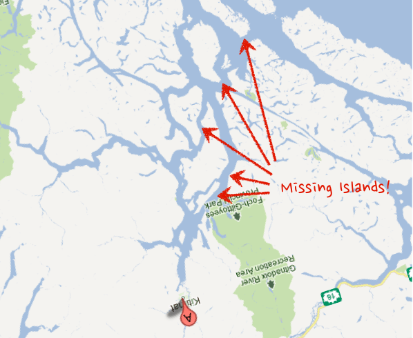
Take a look at the Google Map view of the same area (I’ve pasted a screen shot below – and rotated the map so you are looking at it from the same “standing” location). Notice something missing from Enbridge’s maps?
According to the Ottawa Citizens story an Enbridge spokesperson said their illustration was only meant to be “broadly representational.” Of course, all maps are “representational,” that is what a map is, a representation of reality that purposefully simplifies that reality so as to aid the reader draw conclusions (like how to get from A to B). Of course such a representation can also be used to mislead the reader into drawing the wrong conclusion. In this case, removing 1000 square kilometers that create a complicated body of water to instead show that oil tankers can steam relatively unimpeded up Douglas Channel from the ocean.
The folks over at Leadnow.ca have remade the Enbridge map as it should be:

Rubbing out some – quite large – islands that make this passage much more complicated of course fits Enbridge’s narrative. The problem is, at this point, given how much the company is suffering from the perception that it is not being fully upfront about its past record and the level of risk to the public, presenting a rosy eyed view of the world is likely to diminish the public’s confidence in Enbridge, not increase their confidence in the project.
There is another lesson. This is great example of how facts, data and visualization matter. They do. A lot. And we are, almost every day, being lied to through visual representations from sources we are told to trust. While I know that no one thinks of maps as open or public data in many ways they are. And this is a powerful example of how, when data is open and available, it can enable people to challenge the narratives being presented to them, even when those offering them up are powerful companies backed by a national government.
If you are going to create a representation of something you’d better think through what you are trying to present, and how others are going to see it. In Enbridge’s case this was either an effort at guile gone horribly wrong or a communications strategy hopelessly unaware of the context in which it is operating. Whoever you are, and whatever you are visualization – don’t be like Enbridge – think through your data visualization before you unleash it into the wild.

Pingback: Is Enbridge Northern Gateway Pipeline (Canada) Lying With Maps | AnyGeo - GIS, Maps, Mobile and Social Location Technology
Pingback: Lying with Maps: How Enbridge is Misleading the Public in its Ads « Hands Across New Hampshire
total scumbag corporation. stay outta BC you lying bastards.
interestingly – isn’t that Gil Island? Wasn’t that where the Queen of the North sank several years ago? Why is this not a GLARING WARNING to us that this area is not an easy place to navigate? If a BC ferry can’t navigate that passage safely, then why would we think loaded oil tankers could?
Pingback: Another Week of GW News – August 19, 2012 – A Few Things Ill Considered
Isn’t the implication obvious? Enbridge plans to remove those islands.
isnt it funny the location of the ship in the animation? embridge is promicing a ship will hit a giant island
I trust you saw the YT spoof on same?
Pingback: Focus on Cartography – Is the Enbridge Northern Gateway Pipeline Project (Canada) Lying With Maps?
Pingback: Enbridge Northern Gateway Pipeline (Canada) Lying With Maps | GISuser.com
Pingback: Defending Our Coast: A message from the front lines. - The Starfish Canada