Tag Archives: transit

More on Google Transit and how it is Reshaping a Public Service

Some of you know I’ve written a fair bit on Google transit and how it is reshaping public transit – this blog post in particular comes to mind. For more reading I encourage you to check out the Xconomy article Google Transit: How (and Why) the Search Giant is Remapping Public Transportation as it provides a lot of good details as to what is going on in this space.

Two things about this article:

First, it really is a story about how the secret sauce for success is combining open data with a common standard across jurisdictions. The fact that the General Transit Feed Specification (a structured way of sharing transit schedules) is used by over 400 transit authorities around the world has helped spur a ton of other innovations.

Couple of money quotes include this one about the initial reluctance of some authorities to share their data for free (I’m looking at you Translink board):

“I have watched transit agencies try to monetize schedules for years and nobody has been successful,” he says. “Markets like the MTA and the D.C. Metro fought sharing this data for a very long time, and it seems to me that there was a lot of fallout from that with their riders. This is not our data to hoard—that’s my bottom line.”

and this one about iBart, an app that uses the GTFS to power an app for planning transit trips:

in its home city, San Francisco, the startup’s app continues to win more users: about 3 percent of all trips taken on BART begin with a query on iBART

3%? That is amazing. Last year my home town of Vancouver’s transit authority, Translink, had 211.3 million trips. If the iBart app were ported to here and enjoyed similar success that would man 6.4 million trips planned on iBart (or iTranslink?). That’s a lot of trips made easier to plan.

The second thing I encourage you to think about…

Where else could this model be recreated? What’s the data set, where is the demand from the public, and what is the company or organization that can fulfill the role of google to give it scale. I’d love to hear thoughts.

Research Request – Transit Study

After writing yesterday’s post on the economics of opendata and transit I’ve really been reflecting on a research question that emerged in the piece: Does having transit data embedded in Google Maps increase ridership?

My hypothesis is that it would… but I did some googling on the topic and couldn’t find anything written on the subject, not to mention something that had been rigorously researched and would stand up to peer review. This leads me to believe it could be a great research project. I willing to bet that some transit authorities, and Google would be of enormously interested in the results.

Obviously there are a number of variables that might impact public transit ridership: budgets, fleet size growth or cutbacks, the economy, population growth, etc… That said, I’m sure there is someone out there who could think of a methodology that would account for these factors and still allow us to tell if becoming available in Google Maps impact’s a city’s ridership levels.

The helpful thing is that there are lots of data points to play with. A brief scan of the public transit feed lists suggests that there are roughly 150 cities that provide Google with GTFS data of the transit schedule. That’s a lot of cities to play with and would allow a study to offset regional variations. I’m also confident that each of the transit authorities mentioned in the list publicly publish their ridership levels (or they could be FOIAed/ATIPed)

If anyone has done this study, please let me know, I’d love to know more. If no, and someone is interested in doing this study, please go for it! I’m definitely happy to offer whatever support I can.

The next Open Data battle: Advancing Policy & Innovation through Standards

With the possible exception of weather data, the most successful open data set out there at the moment is transit data. It remains the data with which developers have experimented and innovated the most. Why is this? Because it’s been standardized. Ever since Google and the City of Portland creating the General Transit Feed Specification (GTFS) any developer that creates an application using GTFS transit data can port their application to over 100+ cities around the world with 10s and even 100s of millions of potential users. Now that’s scale!

All in all the benefits of a standard data structure are clear. A public good is more effectively used, citizens receive enjoy better service and companies (both Google and the numerous smaller companies that sell transit related applications) generate revenue, pay salaries, etc…

This is why, with a number of jurisdictions now committed to open data, I believe it is time for advocates to start focusing on the next big issue. How do we get different jurisdictions to align around standard structures so as to increase the number of people to whom an application or analysis will be relevant? Having cities publish open data sets is a great start and has led to real innovation, next generation open data and the next leaps in innovation will require some more standards.

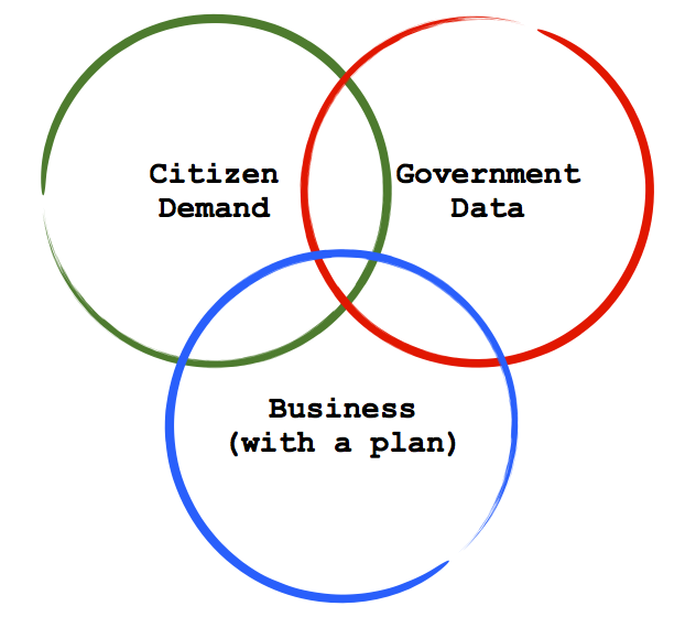
The key, I think, is to find areas that meet three criteria:

  • Government Data: Is there relevant government data about the service or issue that is available?
  • Demand: Is this a service for which there is regular demand? (this is why transit is so good, millions of people touch the service on a daily basis)
  • Business Model: Is there a business that believes it can use this data to generate revenue (either directly, or indirectly)


opendata-1.0151

Two comments on this.

First, I think we should look at this model because we want to find places where the incentives are right for all the key stakeholders. The wrong way to create a data structure is to get a bunch of governments together to talk about it. That process will take 5 years… if we are lucky. Remember the GTFS emerged because Google and Portland got together, after that, everybody else bandwagoned because the value proposition was so high. This remains, in my mind, not the perfect, but the fastest and more efficient model to get more common data structures. I also respect it won’t work for everything, but it can give us more successes to point to.

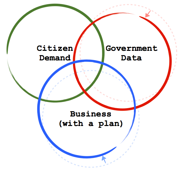
Which leads me to point two. Yes, at the moment, I think that target in the middle of this model is relatively small. But I think we can make it bigger. The GTFS shows cities, citizens and companies that there is value in open data. What we need are more examples so that a) more business models emerge and b) more government data is shared in a structured way across multiple jurisdictions. The bottom and and right hand circles in this diagram can, and if we are successful will, move. In short, I think we can create this dynamic:

opendata4.016

So, what does this look like in practice?

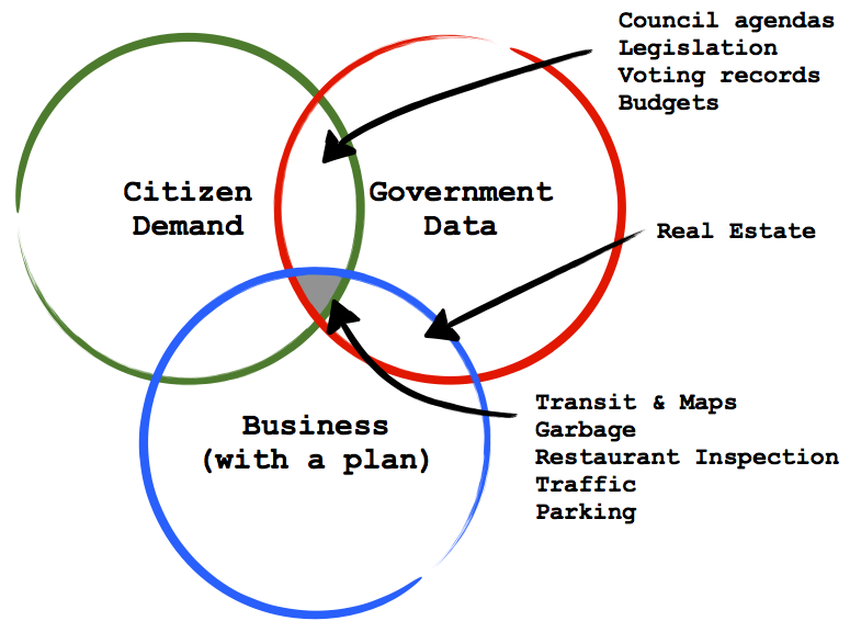
I’ve been trying to think of services that fall in various parts of the diagram. A while back I wrote a post about using open restaurant inspection data to drive down health costs. Specifically around finding a government to work with a Yelp!, Bing or Google Maps, Urban Spoon or other company to integrate the  inspection data into the application. That for me is an example of something that I think fits in the middle. Government’s have the data, its a service citizens could touch on a regular base if the data appeared in their workflow (e.g. Yelp! or Bing Maps) and for those businesses it either helps drive search revenue or gives their product a competitive advantage. The Open311 standard (sadly missing from my diagram), and the emergence of SeeClickFix strike me as another excellent example that is right on the inside edge of the sweet spot).

Here’s a list of what else I’ve come up with at the moment:

opendata3.015

You can also now see why I’ve been working on Recollect.net – our garbage pick up reminder service – and helping develop a standard around garbage scheduling data – the Trash & Recycling Object Notation. I think it is a service around which we can help explain the value of common standards to cities.

You’ll notice that I’ve put “democracy data” (e.g. agendas, minutes, legislation, hansards, budgets, etc…) in the area where I don’t think there is a business plan. I’m not fully convinced of this – I could see a business model in the media space for this – but I’m trying to be conservative in my estimate. In either case, that is the type of data the good people at the Sunlight Foundation are trying to get liberated, so there is at least, non-profit efforts concentrated there in America.

I also put real estate in a category where I don’t think there is real consumer demand. What I mean by this isn’t that people don’t want it, they do, but they are only really interested in it maybe 2-4 times in their life. It doesn’t have the high touch point of transit or garbage schedules, or of traffic and parking. I understand that there are businesses to be built around this data, I love Viewpoint.ca – a site that takes mashes opendata up with real estate data to create a compelling real estate website – but I don’t think it is a service people will get attached to because they will only use it infrequently.

Ultimately I’d love to hear from people on ideas they on why might fit in this sweet spot. (if you are comfortable sharing the idea, of course). Part of this is because I’d love to test the model more. The other reason is because I’m engaged with some governments interested in getting more strategic about their open data use and so these types of opportunities could become reality.

Finally, I just hope you find this model compelling and helpful.

Applications and Hardware Already Running On Open Data

Yesterday, Gerry T shared a photo he snapped at the University of Alberta in Edmonton of a “departure board” in the university’s Student Union building that uses open transportation data from the city’s website.

Essentially the display board is composed of a simply application, displayed over a large flat screen TV turned vertically.

TransitApp_BusDepartures-217x300It’s exactly the kind of thing that I imagine University Students in many cities around the world wish they had – especially if you are on a campus that is cold and/or wet. Wouldn’t it be nice to wait inside that warm student union building rather than at the bus stop?

Of course in Boston they’ve gone further than just providing the schedule online. They provide real-time data on bus locations which some students and engineers have used to create $350 LED signs in coffee houses to let users know when the next bus is coming.

It’s the kind of simple innovations you wish you’d see in more places: government’s letting people help themselves at making their lives a little easier. Yes, this isn’t changing the world, but its a start, and an example of what more could happen.

Mostly it’s nice to see innovators in Canada like playing with the technology. Hopefully governments will catch up and let the even bigger ideas students around the country have be more than just visions in their heads.

Not sure who at the University created this, but nice work.

Urban Public Transit Done Right

Metronauts, eat your hearts out. :)

Was back in Vancouver yesterday. It was a glorious day – the kind that you write in your blog about. Anyway, rode the bus downtown for several meetings and noticed this sign:

text a bus sched

In short, you can now text “33333” + the identifying number found on every bus stop in Vancouver and… the arrival times of the next 6 scheduled buses will be texted to you.

Now this schedule is probably static and does not adjust for the fact that specific buses may be running late, caught in traffic, blown a tire, etc… But it is a start.

Anything that gives transit users more information is a good thing, especially if that means it will raise their expectations around the timeliness and predictability of service (as I suspect this will). A traffic that is more demanding of its public transport is more invested in its public transport.

I can already see the logical next step… Imagine a transit user sends a text to find out when the next bus will arrive. When that bus (and possibly the subsequent bus) fails to show up he/she starts looking for a complaints or information line to call. Their expectation is going to be that the person on the other end of the line can answer the question: “Where is my bus.” The obvious conclusion to this scenario – take the GPS emitters that are on every bus and open up their API’s so that we can all see where they are. It is going to rock transit users’ worlds when they can open up google maps on their phones and search “Vancouver, Transit, 22” and see the current location of all the 22 buses.

Translink you’ve opened a pandora’s box of expectations for this user. It is a good first step.

[BTW: Transit geeks in Vancouver should already be reading this blog, which, of course, was on the case long before me. Long live the long tail of blogs.]

TransitCamp

Want to say congratulations to Jay Goldman, Eli Singer and Mark Kuznicki. Their article on TransitCamp has been published in the February 2008 issue of the Harvard Business Review.

For those unfamiliar with the concept of an unconference – like TransitCamp or the opencities unconference we put on last year – the article is a great starting point.

It’s a wonderful example about how citizens can be engaged in a truly meaningful way. As the website states: TransitCamp was – and will continue to be – a solution playground, not a complaints department. It is as much a celebration of transit as it is a place where people gather to figure out how to make it better.

Much like a NFL game is as much about the tailgating, social/community oriented party in the stadium parking lot as it is about the serious game going on inside the stadium, TransitCamp is as much about celebrating and uniting the transit community as it is about the serious work of figuring out how to make the TTC better.

And, to top it all off, it was a place where ideas get to flourish and are not subjected to consensus and other lowest common denominator approaches.

This, and all sorts of other good reasons, is why HBR made it a breakthrough idea for 2008.

(BTW: Go Pats Go)